This section of the site contains our photographs of natural landscapes of the world, including geological formations, relief forms, natural water bodies and vegetation types, as well as some plants and animals, typical to different native zones and geographical regions.
This page contains the list of images of the "Land of Fire"
(Tierra del Fuego) Archipelago (Argentina, South America) nature:
natural landscapes, vegetation types and some animals.
Clicking on the preview in the list below you will be transferred to the page with the
full sized image
(usually 1024 x 768 pixels and approximately 60 kilobytes).
South America
"Land of Fire" Archipelago
Tierra del Fuego, Argentina
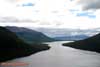
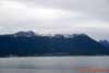
Lake Escondido and Patagonian Andes (South Andes).
Altitudinal vegetation zones are visible - the border between beech deciduous forest and
subantarctic mountain alpine meadows at a height of about 500 meters above sea level.
Ushuaia, "Land of Fire" (Tierra del Fuego), Argentina, South America
Lake Escondido and Patagonian Andes (South Andes).
Altitudinal vegetation zones are visible - the border between beech deciduous forest and
subantarctic mountain alpine meadows at a height of about 500 meters above sea level.
Ushuaia, "Land of Fire" (Tierra del Fuego), Argentina, South America
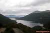
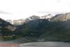
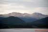
Freshwater Lake Escondido in the Patagonian Andes (South Andes).
Altitudinal vegetation zones are visible - the border between beech deciduous forest and
subantarctic mountain alpine meadows at a height of about 500 meters above sea level.
Ushuaia, "Land of Fire" (Tierra del Fuego), Argentina, South America
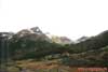
Broadleaved deciduous forest with Winter's Bark, or Canelo (Drimys winteri)
predominance on the border with subantarctic mountain alpine meadows at a height
of about 500 meters above sea level.
Patagonian Andes, "Land of Fire" (Tierra del Fuego), Argentina, South America
Broadleaved deciduous forest with Winter's Bark, or Canelo (Drimys winteri)
predominance on the border with subantarctic mountain alpine meadows at a height
of about 500 meters above sea level.
Patagonian Andes, "Land of Fire" (Tierra del Fuego), Argentina, South America
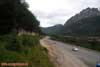
The Pan-American Highway, going through South and North America for 48000 kilometers
and connecting "Land of Fire" (Tierra del Fuego) on the South and Alaska on the
North.
Patagonian Andes, "Land of Fire" (Tierra del Fuego), Argentina, South America
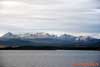
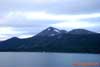
South islands of the "Land of Fire" (Tierra del Fuego) Archipelago - is the
prolongation
of the Patagonian Andes (Patagonian plateau).
View from the Beagle Channel - the strait separating Tierra del Fuego Archipelago
and South America continent.
South islands of the "Land of Fire" (Tierra del Fuego) Archipelago - is the
prolongation
of the Patagonian Andes (Patagonian plateau).
View from the Beagle Channel - the strait separating Tierra del Fuego Archipelago
and South America continent.
South islands of the "Land of Fire" (Tierra del Fuego) Archipelago from the
Beagle Channel.
Altitudinal vegetation zones are visible - the border between beech deciduous forest and
subantarctic mountain alpine meadows at a height of about 500 meters above sea level.
Patagonian Andes, "Land of Fire" (Tierra del Fuego), Argentina, South America
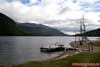
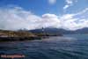
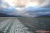
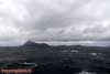
The Beagle Channel - the strait separating Tierra del Fuego Archipelago and South
America continent.
Patagonian Andes, "Land of Fire" (Tierra del Fuego), Argentina, South America
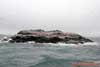
One of the southern islands of the "Land of Fire" (Tierra del Fuego)
Archipelago in the Beagle Channel -
the strait separating Tierra del Fuego Archipelago and South America continent.
The "Land of Fire" (Tierra del Fuego), Argentina, South America
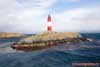
The lighthouse on the small island of the "Land of Fire" (Tierra del Fuego)
Archipelago
in the Beagle Channel. The "Land of Fire" (Tierra del Fuego), Argentina, South
America
The Beagle Channel - the strait separating Tierra del Fuego Archipelago and South
America continent.
Argentina, South America
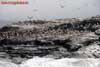
The sea-bird colony on the small island of the "Land of Fire" (Tierra del
Fuego) Archipelago
in the Beagle Channel. The "Land of Fire" (Tierra del Fuego), Argentina, South
America
The sea-bird colony with the Antarctic Cormorant, or Shag (Phalacrocorax
bransfieldensis)
(Phalacrocoracidae Family) predominance on the small island in the Beagle Channel.
The "Land of Fire" (Tierra del Fuego) south extremity, Argentina, South America
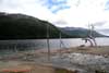
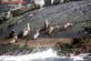
The South American sea lion (Otaria byronia) (Otariidae Family) rookery (colony)
on the small island in the Beagle Channel.
The "Land of Fire" (Tierra del Fuego) south extremity, Argentina, South America
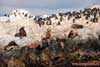
The colony of the Antarctic Cormorants (Antarctic Shag, Phalacrocorax bransfieldensis)
and
South American sea lion (Otaria byronia) rookery (colony) on the small island in the
Beagle Channel.
The "Land of Fire" (Tierra del Fuego) south extremity, Argentina, South America
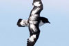
The Pintado Petrel, or Cape Petrel (Daption capensis) (Procellariidae Family).
The Beagle Channel, "Land of Fire" (Tierra del Fuego) south extremity,
Argentina, South America
The Cape Horn - the southernmost tip of South America.
The "Land of Fire" (Tierra del Fuego) south extremity, Argentina, South America.
The Antarctic peninsula is further...