This section of the site contains our photographs of natural landscapes of the world, including geological formations, relief forms, natural water bodies and vegetation types, as well as some plants and animals, typical to different native zones and geographical regions.
This page contains the list of images of the New Zealand South Island
nature: natural landscapes, vegetation types and some plants and animals.
Clicking on the preview in the list below you will be transferred to the page with the
full sized image
(each photo has a semantic geographical or biological captions, explaining illustrated objects).
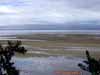
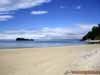
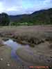
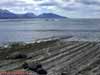
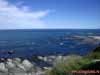
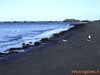
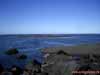
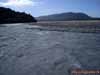
Coastal sandy sediments on the littoral during low tide.
Abel Tasman National Park, Tasman Sea.
Nelson region, northern part of the South Island, New Zealand
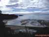
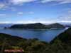
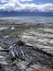
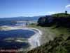
Low tide in the "Sandy Bay". On the foreground is a spit, separated the
lagoon from the sea.
On the background is a "Fisherman Island".
Abel Tasman National Park, Tasman Sea.
Nelson region, northern part of the South Island, New Zealand
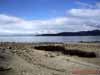
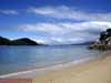
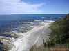
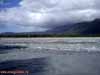
Sandy-shingle beach on the shore of the Tasman Sea.
Abel Tasman National Park, Tasman Sea.
Nelson region, northern part of the South Island, New Zealand
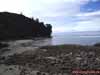
Sandy-shingle beach in the Tasman Sea bay.
Abel Tasman National Park, Tasman Sea.
Nelson region, northern part of the South Island, New Zealand
Sandy beach on the shore of Tasman Sea. "Fisherman Island" is far away.
Abel Tasman National Park, Tasman Sea.
Nelson region, northern part of the South Island, New Zealand
Sandy beach on the shore of Tasman Sea.
Abel Tasman National Park, Tasman Sea.
Nelson region, northern part of the South Island, New Zealand
Sandy beach on the shore of Tasman Sea.
Abel Tasman National Park, Tasman Sea.
Nelson region, northern part of the South Island, New Zealand
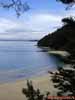
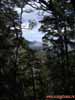
Coastal forest on the Tasman Sea bay. View to the Anchorage Bay.
Abel Tasman National Park, Tasman Sea.
Nelson region, northern part of the South Island, New Zealand
Coastal forest on the Tasman Sea bay. View to the Adele Island.
Abel Tasman National Park, Tasman Sea.
Nelson region, northern part of the South Island, New Zealand
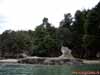
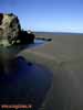
Basalt outlier on the bank of Tasman Sea.
Abel Tasman National Park, Tasman Sea.
Nelson region, northern part of the South Island, New Zealand
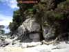
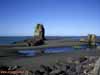
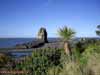
Surf niche "Kiwi" on the bank of Tasman Sea.
Abel Tasman National Park, Tasman Sea.
Nelson region, northern part of the South Island, New Zealand
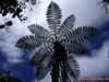
The New Zealand Tree Fern, or Wheki in Maori (Dicksonia squarrosa)
(may be Soft Tree Fern, Man Fern or Tasmanian Tree Fern - Dicksonia antarctica).
Abel Tasman National Park, Tasman Sea.
Nelson region, northern part of the South Island, New Zealand
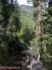
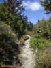
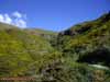
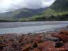
Coastal river valley and Marahau river flowing into Tasman Sea.
Abel Tasman National Park, Tasman Sea.
Nelson region, northern part of the South Island, New Zealand
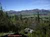
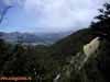
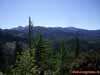
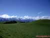
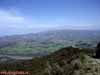
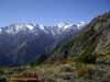
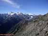
Anthropogenic landscape and view to the Hanmer Springs
and Spenser Mountains.
View from the "Conical Hill" (550 meters above sea level).
Hanmer Springs national park, Canterbury region, eastern part of the South Island, New
Zealand
Mixed conifer-deciduous forest at the foot of the "Conical Hill" (550 meters
above sea level).
Hanmer Springs national park, Canterbury region, eastern part of the South Island, New
Zealand
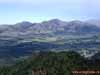
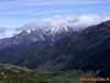
View to the Hanmer Springs valley and Spenser Mountains.
Altitude is about 600 meters above sea level. Conical Hill is on the foreground.
Hanmer Springs national park, Canterbury region, eastern part of the South Island, New
Zealand
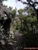
Coniferous sparse growth (elfin wood) on the slope of Mount Isobel.
Altitude is about 600 meters above sea level. Hanmer Springs national park.
The Canterbury region, eastern part of the South Island, New Zealand
Coniferous forest with Monterey Pine (Pinus radiata) predominance on the foreground
and Hanmer Springs valley and Spenser Mountains on the background (700 meters above sea
level).
Hanmer Springs national park, Canterbury region, eastern part of the South Island, New
Zealand
Coniferous forest with Monterey Pine (Pinus radiata) predominance on the foreground
and Hanmer Springs valley and Spenser Mountains on the background (700 meters above sea
level).
Hanmer Springs national park, Canterbury region, eastern part of the South Island, New
Zealand
Broadleaved deciduous forest with Mountain Beech (Nothofagus solandri),
Marble leaf, Putaputaweta (Carpodetus serratus), Five Finger (Pseudopanax arboreus).
700 meters above sea level, Hanmer Springs national park, Canterbury region,
eastern part of the South Island, New Zealand
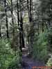
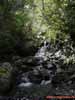
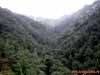
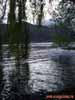
Mountain creek in the deciduous forest zone.
700 meters above sea level, Hanmer Springs national park, Canterbury region,
eastern part of the South Island, New Zealand
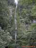
Dog Stream Waterfall in the deciduous forest zone.
700 meters above sea level, Hanmer Springs national park, Canterbury region,
eastern part of the South Island, New Zealand
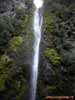
Dog Stream Waterfall in the deciduous forest zone.
700 meters above sea level, Hanmer Springs national park, Canterbury region,
eastern part of the South Island, New Zealand
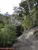
Mixed conifer-deciduous forest with Monterey Pine (Pinus radiata), Lawson's cypress
(Chamaecyparis lawsoniana) and Silver Birch (Betula pendula).
800 meters above sea level, Hanmer Springs national park, Canterbury region,
eastern part of the South Island, New Zealand
Coniferous forest with Monterey Pine (Pinus radiata), Lawson's cypress (Chamaecyparis
lawsoniana),
Japanese cypress, Hinoki cypress or Hinoki (Chamaecyparis obtusa), Atlas Cedar (Cedrus
atlantica),
Douglasfir (Pseudotsuga), Golden Chain (Laburnum), giant fir, poplar in the underbrush.
800 meters above sea level, Hanmer Springs national park, Canterbury region,
eastern part of the South Island, New Zealand
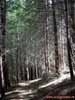
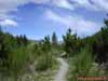
Coniferous forest with Monterey Pine (Pinus radiata).
1000 meters above sea level, Hanmer Springs national park, Canterbury region,
eastern part of the South Island, New Zealand
Coniferous forest with Monterey Pine (Pinus radiata).
1000 meters above sea level, Hanmer Springs national park, Canterbury region,
eastern part of the South Island, New Zealand
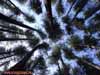
Coniferous forest with Monterey Pine (Pinus radiata) - undercrown view.
1000 meters above sea level, Hanmer Springs national park, Canterbury region,
eastern part of the South Island, New Zealand
Narrowleaved deciduous forest with birch predominance.
(probably Silver Birch - Betula pendula var. platyphylla).
1100 meters above sea level, Hanmer Springs national park, Canterbury region,
eastern part of the South Island, New Zealand
Coniferous sparse growth (elfin wood) on the 1200 meters above sea level.
Hanmer Springs national park, Canterbury region, eastern part of the South Island, New
Zealand
Coniferous sparse growth (elfin wood) on the 1200 meters above sea level.
Hanmer Springs national park, Canterbury region, eastern part of the South Island, New
Zealand
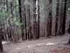
Coniferous pine forests in the high altitude forest zone.
1200 meters above sea level.
Hanmer Springs national park, Canterbury region, eastern part of the South Island, New
Zealand
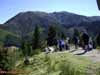
Outdoor lesson in the coniferous pine forest zone.
1200 meters above sea level.
Hanmer Springs national park, Canterbury region, eastern part of the South Island, New
Zealand
Coniferous pine forests in the high altitude forest zone.
1200 meters above sea level.
Hanmer Springs national park, Canterbury region, eastern part of the South Island, New
Zealand
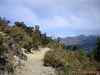
Altitude vegetation zones at the Mount Isobel slopes. Upper boundary of the forest
zone.
1300 meters above sea level, subalpine meadows zone.
Hanmer Springs national park, Canterbury region, eastern part of the South Island, New
Zealand
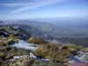
View to the Mount Isobel. 1300 meters above sea level, subalpine meadows zone.
Hanmer Springs national park, Canterbury region, eastern part of the South Island, New
Zealand
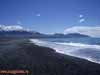
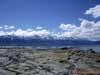
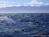
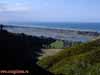
Shingle beach on the Pacific Ocean shore.
View to the Seaward Kaikoura (about 2000 m height).
Kaikoura district, Canterbury region, north-eastern part of the South Island, New Zealand
Shingle beach on the Pacific Ocean shore.
View to the Seaward Kaikoura (about 2000 m height).
Kaikoura district, Canterbury region, north-eastern part of the South Island, New Zealand
Shingle beach on the Pacific Ocean shore.
View to the Seaward Kaikoura (about 2000 m height).
Kaikoura district, Canterbury region, north-eastern part of the South Island, New Zealand
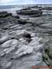
The scarp - undulating (wave) erosion zone. Pacific ocean coast.
Kaikoura district, Canterbury region, north-eastern part of the South Island, New Zealand
The scarp - undulating (wave) erosion zone. Pacific ocean coast.
Kaikoura district, Canterbury region, north-eastern part of the South Island, New Zealand
Karst scarp - undulating (wave) erosion zone. Pacific ocean coast.
Kaikoura district, Canterbury region, north-eastern part of the South Island, New Zealand
Laminaria (Brown algae - Phaeophyceae) on the Pacific ocean shore.
Kaikoura district, Canterbury region, north-eastern part of the South Island, New Zealand
The scarp - undulating (wave) erosion zone. Pacific ocean coast.
Kaikoura district, Canterbury region, north-eastern part of the South Island, New Zealand
The scarp - undulating (wave) erosion zone. Pacific ocean coast.
Kaikoura district, Canterbury region, north-eastern part of the South Island, New Zealand
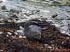
New Zealand Fur Seal (Arctocephalus forsteri) on the Pacific ocean shore.
Kaikoura district, Canterbury region, north-eastern part of the South Island, New Zealand
New Zealand Fur Seal (Arctocephalus forsteri) on the Pacific ocean shore.
Kaikoura district, Canterbury region, north-eastern part of the South Island, New Zealand
New Zealand Fur Seal (Arctocephalus forsteri) on the Pacific ocean shore.
Kaikoura district, Canterbury region, north-eastern part of the South Island, New Zealand
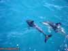
Dusky Dolphins (Lagenorhynchus obscurus) in the Pacific ocean waters.
Kaikoura district, Canterbury region, north-eastern part of the South Island, New Zealand
Cachalots under the water.Pacific ocean.
Kaikoura district, Canterbury region, north-eastern part of the South Island, New Zealand
Coastal shrubs on the edge of the beach. View to the Seaward Kaikoura (about 2000 m
height).
Kaikoura district, Canterbury region, north-eastern part of the South Island, New Zealand
The scarp - undulating (wave) erosion zone. Pacific ocean coast.
Kaikoura district, Canterbury region, north-eastern part of the South Island, New Zealand
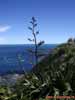
New Zealand flax, or New Zealand hemp (Phormium tenax) (Hemerocallidaceae family) -
perennial subshrub, suffrutex.
Kaikoura district, Canterbury region, north-eastern part of the South Island, New Zealand
The scarp - undulating (wave) erosion zone with karst elements. Pacific ocean coast.
Kaikoura district, Canterbury region, north-eastern part of the South Island, New Zealand
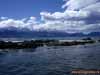
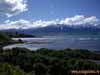
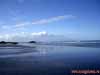
Pacific ocean bay near the Kaikoura peninsula.
Kaikoura district, Canterbury region, north-eastern part of the South Island, New Zealand
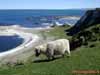
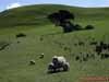
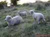
New Zealand sheep.
Kaikoura district, Canterbury region, north-eastern part of the South Island, New Zealand
Undulating (wave) erosion zone in the Kaikoura Bay.
Kaikoura district, Canterbury region, north-eastern part of the South Island, New Zealand
Pride of Madeira (Echium candicans = Echium fastuosum J.Jacq.).
Kaikoura district, Canterbury region, north-eastern part of the South Island, New Zealand
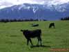
The herd of cattle against the background of Seaward Kaikoura (about 2000 m height).
Kaikoura district, Canterbury region, north-eastern part of the South Island, New Zealand
The herd of cattle against the background of Seaward Kaikoura (about 2000 m height).
Kaikoura district, Canterbury region, north-eastern part of the South Island, New Zealand
New Zealand sheep.
Kaikoura district, Canterbury region, north-eastern part of the South Island, New Zealand
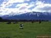
The pasture.
Kaikoura district, Canterbury region, north-eastern part of the South Island, New Zealand
The pasture on the coastal lowland.
Kaikoura district, Canterbury region, north-eastern part of the South Island, New Zealand
The scarp - undulating (wave) erosion zone on the Kaikoura peninsula.
Kaikoura district, Canterbury region, north-eastern part of the South Island, New Zealand
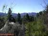
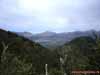
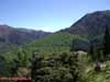
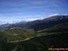
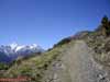
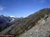
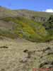
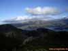
View to the Kaikoura valley. 400 meters above sea level.
Kaikoura district, Canterbury region, north-eastern part of the South Island, New Zealand
View to the Kaikoura valley. 800 meters above sea level.
Kaikoura district, Canterbury region, north-eastern part of the South Island, New Zealand
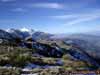
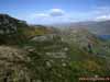
Seaward Kaikoura mountains slope. 800 meters above sea level.
Kaikoura district, Canterbury region, north-eastern part of the South Island, New Zealand
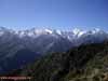
Altitude vegetation in the upper forest zone (1000-1100 meters above sea level).
Seaward Kaikoura mountains.
Kaikoura district, Canterbury region, north-eastern part of the South Island, New Zealand
View to the Seaward Kaikoura mountains in the upper forest zone
(1100-1200 meters above sea level).
Kaikoura district, Canterbury region, north-eastern part of the South Island, New Zealand
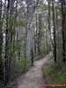
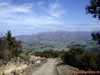
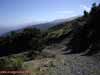
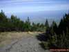
Mountain road in the subalpine zone (1100-1200 meters above sea level).
Kaikoura district, Canterbury region, north-eastern part of the South Island, New Zealand
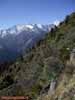
Altitude vegetation in the subalpine zone (1100-1200 meters above sea level).
Seaward Kaikoura mountains.
Kaikoura district, Canterbury region, north-eastern part of the South Island, New Zealand
Coniferous sparse growth (elfin wood) in the subalpine zone (1200 meters above sea
level).
Seaward Kaikoura mountains.
Kaikoura district, Canterbury region, north-eastern part of the South Island, New Zealand
Coniferous sparse growth (elfin wood) in the subalpine zone (1200 meters above sea
level).
Seaward Kaikoura mountains.
Kaikoura district, Canterbury region, north-eastern part of the South Island, New Zealand
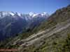
Altitude vegetation in the subalpine zone (1300 meters above sea level).
Seaward Kaikoura mountains.
Kaikoura district, Canterbury region, north-eastern part of the South Island, New Zealand
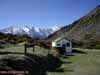
Tourist shelter in subalpine zone (1300 meters above sea level).
Seaward Kaikoura mountains.
Kaikoura district, Canterbury region, north-eastern part of the South Island, New Zealand
View to the Kaikoura peninsula from the Seaward Kaikoura mountains.
Kaikoura district, Canterbury region, north-eastern part of the South Island, New Zealand
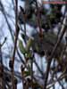
Spring in the mountains. The alder in a full bud.
Kaikoura district, Canterbury region, north-eastern part of the South Island, New Zealand
Altitude vegetation in the alpine meadows zone (1500 above sea level).
Seaward Kaikoura mountains.
Kaikoura district, Canterbury region, north-eastern part of the South Island, New Zealand
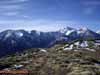
Seaward Kaikoura mountains in the alpine meadows zone (1500 above sea level).
Kaikoura district, Canterbury region, north-eastern part of the South Island, New Zealand
Altitude vegetation in the alpine meadows zone (1500 above sea level).
Seaward Kaikoura mountains.
Kaikoura district, Canterbury region, north-eastern part of the South Island, New Zealand
Altitude vegetation in the alpine meadows zone (1500 above sea level).
Seaward Kaikoura mountains.
Kaikoura district, Canterbury region, north-eastern part of the South Island, New Zealand
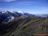
View from the Mount Fyffe (1602 м) in the alpine meadows zone.
Seaward Kaikoura mountains.
Kaikoura district, Canterbury region, north-eastern part of the South Island, New Zealand
Seaward Kaikoura mountains in the alpine meadows zone (1500 above sea level).
Kaikoura district, Canterbury region, north-eastern part of the South Island, New Zealand
Seaward Kaikoura mountains in the alpine meadows zone (1500 above sea level).
Kaikoura district, Canterbury region, north-eastern part of the South Island, New Zealand
Seaward Kaikoura mountains in the alpine meadows zone (1500 above sea level).
Kaikoura district, Canterbury region, north-eastern part of the South Island, New Zealand
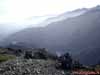
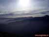
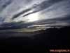
Evening cloudiness in the Seaward Kaikoura mountains (1500 above sea level).
Kaikoura district, Canterbury region, north-eastern part of the South Island, New Zealand
Evening cloudiness in the Seaward Kaikoura mountains (1500 above sea level).
Kaikoura district, Canterbury region, north-eastern part of the South Island, New Zealand
Sandy beach on the Pacific Ocean coast near Barnett Park.
Christchurch area, Canterbury region, eastern part of the South Island, New Zealand
Sandy beach on the Pacific Ocean coast. Black Backed Gulls, or Karoro (Larus
dominicanus).
Barnett Park, Christchurch area, Canterbury region, eastern part of the South Island, New
Zealand
Sandy spits on the Pacific Ocean coast.
Barnett Park, Christchurch area, Canterbury region, eastern part of the South Island, New
Zealand
Sandy beach with basalt outlier on the Pacific Ocean coast.
Barnett Park, Christchurch area, Canterbury region, eastern part of the South Island, New
Zealand
Sandy beach with basalt outlier on the Pacific Ocean coast.
Barnett Park, Christchurch area, Canterbury region, eastern part of the South Island, New
Zealand
Sandy beach with basalt outlier on the Pacific Ocean coast.
Pride of Madeira (Echium candicans = Echium fastuosum J.Jacq.) and
Cabbage Palm (Cordyline australis) on the foreground.
Barnett Park, Christchurch area, Canterbury region, eastern part of the South Island, New
Zealand
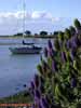
Small bay of the Pacific Ocean. Pride of Madeira
(Echium candicans = Echium fastuosum J.Jacq.) on the foreground.
Barnett Park, Christchurch area, Canterbury region, eastern part of the South Island, New
Zealand
Sandbar and lagoon on the Pacific ocean coast. Christchurch city on the sandbar.
Barnett Park, Christchurch area, Canterbury region, eastern part of the South Island, New
Zealand
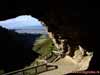
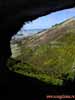
Grotto (karst origin) near Christchurch city, that is situated on the sandbar,
separating the lagoon from the ocean.
Barnett Park, Christchurch area, Canterbury region, eastern part of the South Island, New
Zealand
Hill slope covered with xerophyte vegetation (view from the grotto).
Barnett Park, Christchurch area, Canterbury region, eastern part of the South Island, New
Zealand
Hill slope covered xerophyte vegetation (with Common Gorse - Ulex europaeus,
predominance).
Barnett Park, Christchurch area, Canterbury region, eastern part of the South Island, New
Zealand
Hill slope covered xerophyte vegetation (with Common Gorse - Ulex europaeus,
predominance).
Barnett Park, Christchurch area, Canterbury region, eastern part of the South Island, New
Zealand
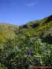
Xerophyte meadows vegetation with Kangaroo Apple (Solanum laciniatum).
Barnett Park, Christchurch area, Canterbury region, eastern part of the South Island, New
Zealand
Xerophyte meadows vegetation with Kangaroo Apple (Solanum laciniatum).
Barnett Park, Christchurch area, Canterbury region, eastern part of the South Island, New
Zealand
Subalpine meadows in the Lyttelton city outskirts.
Christchurch area, Canterbury region, eastern part of the South Island, New Zealand
New Zealand sheep.
Christchurch area, Canterbury region, eastern part of the South Island, New Zealand
Sea bay and Lyttelton harbour.
Christchurch district, Canterbury region, eastern part of the South Island, New Zealand
Sandbar and lagoon on the Pacific ocean coast. Christchurch city on the sandbar.
Christchurch district, Canterbury region, eastern part of the South Island, New Zealand
View to the Lyttelton harbour.
Lyttelton city outskirts, Christchurch district, Canterbury region,
eastern part of the South Island, New Zealand
Subalpine xerophyte meadows at 900 meters above sea level.
Lyttelton city outskirts, Christchurch district, Canterbury region,
eastern part of the South Island, New Zealand
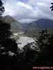
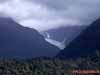
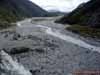
Waiho river, flowing from the France Joseph Glacier.
Broadleaved deciduous forest zone.
West-coast region, western coast of the South Island, New Zealand
Waiho river, flowing from the France Joseph Glacier. Broadleaved deciduous forest
zone.
West-coast region, western coast of the South Island, New Zealand
Waiho river, flowing from the France Joseph Glacier.
West-coast region, western coast of the South Island, New Zealand
Waiho river, flowing from the France Joseph Glacier.
West-coast region, western coast of the South Island, New Zealand
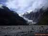
France Joseph Glacier far away slipping down from the Southern Alps mountains.
Westland National Park, West-coast region, South Island, New Zealand
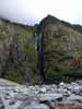
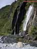
Mountain waterfall on the slope of France Joseph Glacier ancient valley.
Westland National Park, West-coast region, South Island, New Zealand
Mountain waterfall on the slope of France Joseph Glacier ancient valley.
Westland National Park, West-coast region, South Island, New Zealand
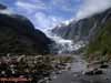
France Joseph Glacier far away slipping down from the Southern Alps mountains.
Westland National Park, West-coast region, South Island, New Zealand
France Joseph Glacier far away slipping down from the Southern Alps mountains.
Westland National Park, West-coast region, South Island, New Zealand
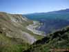
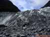
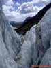
France Joseph Glacier ablation zone (zone of ice thawing and destruction).
Westland National Park, West-coast region, South Island, New Zealand
France Joseph Glacier ablation zone (zone of ice thawing and destruction).
Westland National Park, West-coast region, South Island, New Zealand
Waiho river, flowing from the France Joseph Glacier. View from the glacier.
West-coast region, western coast of the South Island, New Zealand
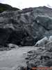
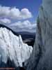
France Joseph Glacier body and glacier stream, flowing from the ice.
Westland National Park, West-coast region, South Island, New Zealand
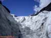
Lower part of the France Joseph Glacier body.
Westland National Park, West-coast region, South Island, New Zealand
Glacier arch made by the melted water, flowing from France Joseph Glacier.
Westland National Park, West-coast region, South Island, New Zealand
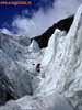
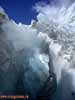
Ice clefts (cracks) in the glacier body formed during melting process.
France Joseph Glacier, Westland National Park, West-coast region, South Island, New
Zealand
Ice clefts (cracks) in the glacier body formed during melting process.
France Joseph Glacier, Westland National Park, West-coast region, South Island, New
Zealand
France Joseph Glacier body.
Westland National Park, West-coast region, South Island, New Zealand
The valley of Waiho river, flowing from the France Joseph Glacier.
West-coast region, western coast of the South Island, New Zealand
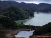
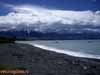
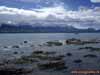
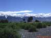
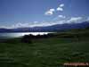
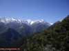
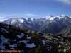
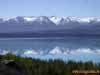
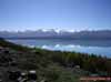
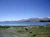
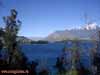
Lake Pukaki - the typical mountain (alpine) oligotrophic
(with low nutrient level) glacial lake.
480 meters above sea level. Southern (New Zealand) Alps.
Mount Cook (the highest peak in New Zealand) is far away on the left (3764 m height).
Canterbury region, South Island, New Zealand
Lake Pukaki - the typical mountain (alpine) oligotrophic (with low nutrient level)
glacial lake.
480 meters above sea level. Southern (New Zealand) Alps.
Canterbury region, South Island, New Zealand
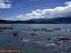
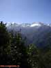
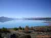
Lake Pukaki - the typical mountain (alpine) oligotrophic (with low nutrient level)
glacial lake.
480 meters above sea level. Southern (New Zealand) Alps.
Mount Cook (the highest peak in New Zealand) is far away in the middle (3764 m height).
Canterbury region, South Island, New Zealand
Lake Pukaki - the typical mountain (alpine) oligotrophic (with low nutrient level)
glacial lake.
480 meters above sea level. Southern (New Zealand) Alps.
Canterbury region, South Island, New Zealand
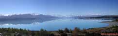
Panorama of the Lake Pukaki - the typical
mountain (alpine) oligotrophic
(with low nutrient level) glacial lake. 480 meters above sea level.
Southern (New Zealand) Alps. Mount Cook (the highest peak in New Zealand)
is far away in the middle (3764 m height). Canterbury region, South Island, New Zealand
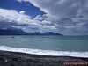
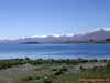
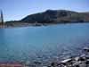
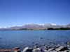
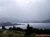
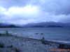
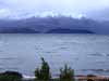
Lake Tekapo - the typical mountain (alpine) oligotrophic
(with low nutrient level) glacial lake.
700 meters above sea level. Southern (New Zealand) Alps.
Canterbury region, South Island, New Zealand
Lake Tekapo - the typical mountain (alpine) oligotrophic (with low nutrient level)
glacial lake.
700 meters above sea level. Southern (New Zealand) Alps.
Canterbury region, South Island, New Zealand
Lake Tekapo - the typical mountain (alpine) oligotrophic (with low nutrient level)
glacial lake.
700 meters above sea level. Southern (New Zealand) Alps.
Canterbury region, South Island, New Zealand
Lake Tekapo - the typical mountain (alpine) oligotrophic (with low nutrient level)
glacial lake.
700 meters above sea level. Southern (New Zealand) Alps.
Canterbury region, South Island, New Zealand
Lake Tekapo - the typical mountain (alpine) oligotrophic (with low nutrient level)
glacial lake.
700 meters above sea level. Southern (New Zealand) Alps.
Canterbury region, South Island, New Zealand
Lake Tekapo - the typical mountain (alpine) oligotrophic (with low nutrient level)
glacial lake.
700 meters above sea level. Southern (New Zealand) Alps.
Canterbury region, South Island, New Zealand
Lake Tekapo - the typical mountain (alpine) oligotrophic (with low nutrient level)
glacial lake.
700 meters above sea level. Southern (New Zealand) Alps.
Canterbury region, South Island, New Zealand
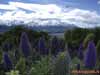
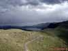
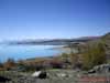
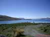
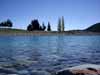
Lake Wanaka - mesotrophic mountain lake (with an
intermediate level of productivity).
300 meters above sea level. Southern (New Zealand) Alps.
Otago region, south-east part of South Island, New Zealand
Lake Wanaka - mesotrophic mountain lake (with an intermediate level of productivity).
300 meters above sea level. Southern (New Zealand) Alps.
Otago region, south-east part of South Island, New Zealand
Lake Wanaka - mesotrophic mountain lake (with an intermediate level of productivity).
300 meters above sea level. Southern (New Zealand) Alps.
Otago region, south-east part of South Island, New Zealand
Lake Wanaka - mesotrophic mountain lake (with an intermediate level of productivity).
300 meters above sea level. Southern (New Zealand) Alps.
Otago region, south-east part of South Island, New Zealand
Lake Wanaka - mesotrophic mountain lake (with an intermediate level of productivity).
300 meters above sea level. Southern (New Zealand) Alps.
Otago region, south-east part of South Island, New Zealand
Lake Wanaka - mesotrophic mountain lake (with an intermediate level of productivity).
300 meters above sea level. Southern (New Zealand) Alps.
Otago region, south-east part of South Island, New Zealand
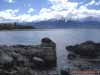
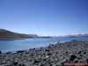
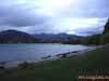
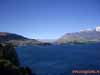
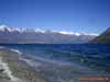
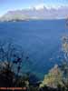
Lake Wakatipu - inland glacial lake (finger lake) (310
meters above sea level)
and Garvie Mountains on the background. Southern (New Zealand) Alps.
Queenstown area, Otago region, south-east part of South Island, New Zealand
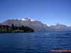
Lake Wakatipu - inland glacial lake (finger lake) (310 meters above sea level)
and Garvie Mountains on the background. Southern (New Zealand) Alps.
Queenstown area, Otago region, south-east part of South Island, New Zealand
Lake Wakatipu - inland glacial lake (finger lake) (310 meters above sea level)
and Garvie Mountains on the background. Southern (New Zealand) Alps.
Queenstown area, Otago region, south-east part of South Island, New Zealand
Lake Wakatipu - inland glacial lake (finger lake) (310 meters above sea level)
and Garvie Mountains on the background. Southern (New Zealand) Alps.
Queenstown area, Otago region, south-east part of South Island, New Zealand
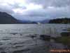
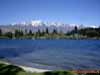
The shore of the Wakatipu Lake - inland glacial lake (finger lake) (310 meters above
sea level).
Southern (New Zealand) Alps.
Queenstown area, Otago region, south-east part of South Island, New Zealand
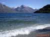
Lake Wakatipu - inland glacial lake (finger lake) (310 meters above sea level)
and Garvie Mountains on the background.
Southern (New Zealand) Alps.
Queenstown area, Otago region, south-east part of South Island, New Zealand
The shore of the Wakatipu Lake - inland glacial lake (finger lake) (310 meters above
sea level)
and Garvie Mountains on the background.
Southern (New Zealand) Alps.
Queenstown area, Otago region, south-east part of South Island, New Zealand
Lake Wakatipu - inland glacial lake (finger lake) (310 meters above sea level)
and Garvie Mountains on the background.
Southern (New Zealand) Alps.
Queenstown area, Otago region, south-east part of South Island, New Zealand